
Pricing for satellite soil intelligence
Pay per hectare for soil analysis, vegetation monitoring, and reports. Volume pricing is available for large areas, and partners can integrate via API.
Soil Analysis
5 €
/hectare
One-off satellite analysis of your field’s nutrients, chemistry, and texture. No sampling required.
Historical analyses (older than 12 months) priced separately. How it works → · Documentation →
Vegetation Monitoring
2.50 €
/hectare / year
Continuous crop monitoring with 11 vegetation indices, updated weekly. Includes 3 years of historical imagery on activation.
Yearly subscription, billed once. How it works → · Documentation →
Better together: soil + vegetation
Soil analysis tells you what the ground has. Vegetation monitoring tells you how the crop is responding. Combine them to close the loop between soil condition and field performance.
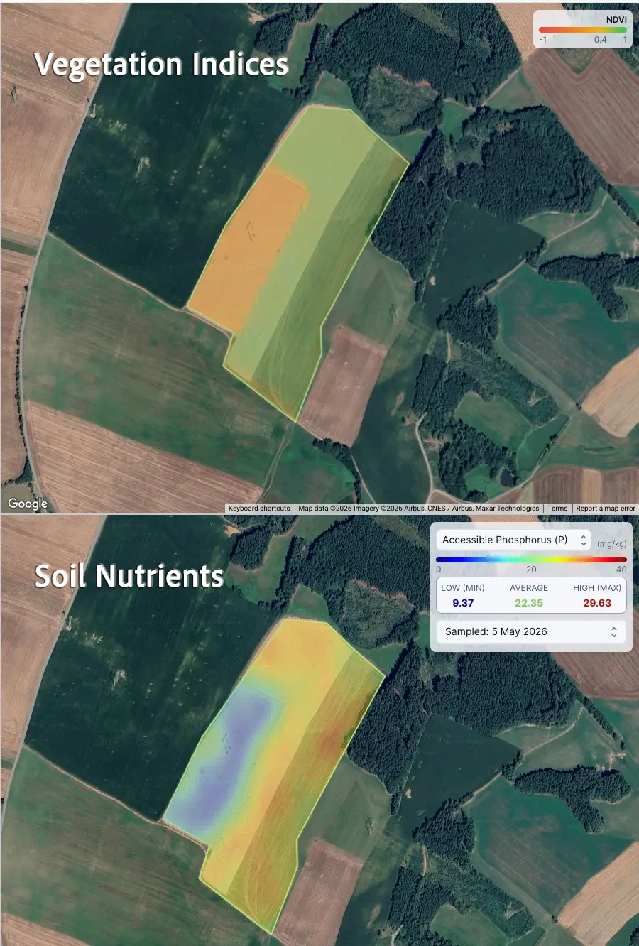
Why both?
Diagnose, then track. Start with a soil analysis to understand baseline nutrients, then use vegetation monitoring to watch how the crop responds week by week.
Catch what one product misses. Low NDVI in a healthy-soil zone points to pest, disease, or water issues, not chemistry. Healthy NDVI on a low-P zone tells you the crop is coping for now but may run out of reserves.
Plan the next intervention with evidence. Combining soil chemistry with in-season vegetation response gives you a defensible basis for variable-rate inputs, replant decisions, or rotation planning.
Pricing FAQ
Answers to the most common questions about plans, billing, and what you receive.
What’s included with each product?
Soil Analysis returns nutrient and soil property maps for your field, plus exportable data and a summary report. Vegetation Monitoring returns 11 vegetation indices for every clear-sky satellite acquisition, with 3 years of historical imagery and weekly updates throughout the subscription year. Both products include PDF, CSV, and Shapefile exports.
How is pricing calculated?
Pricing is based on total hectares submitted. If you analyze multiple fields, pricing is calculated from the combined area. Larger areas can qualify for volume pricing. Soil Analysis is billed per order based on field size. Vegetation Monitoring is a yearly subscription billed once at activation, also based on field size. See the Solutions page for volume pricing and partner integrations.
Can I combine Soil Analysis with Vegetation Monitoring on the same field?
Yes. They’re separate products and billed independently. Many users start with a one-off Soil Analysis to understand baseline conditions, then add Vegetation Monitoring to track crop response across the season. Read more in the Soil Analysis docs and Vegetation Monitoring docs.
Is there a minimum order size?
Yes. The minimum billable area is 1 hectare per order. If your field is smaller, it will be billed as 1 hectare.
How fast do I get results?
Soil Analysis results are typically delivered within minutes of submission. Vegetation Monitoring activates within 24 hours and then refreshes weekly throughout the subscription year. Delivery for both depends on imagery availability and conditions like cloud cover for optical data. See the Vegetation Monitoring documentation for update cadence details.
Do you offer API or white-label pricing?
Yes. If you want to integrate Siora into your platform or advisory workflow, we offer API and partner plans. Contact us with expected volume and geography. You can also explore partner integrations and solutions.
Can I get a sample output before buying?
Yes. We can share an example output so you understand the map layers and data format. You can also browse the Open Soil Datasets to see the packaging and structure. For Vegetation Monitoring, see the documentation for example dashboard outputs.
Or try out our Open Soil Datasets
We routinely generate open, country-scale soil datasets to advance transparency and research in precision agriculture.
Browse open soil nutrient datasets
Download free, country and region-scale soil nutrient datasets (GeoTIFF, PNG heatmaps, and metadata) released under CC BY 4.0. Examples: Murcia, Spain and Ukraine.