Understanding the Foundation of Precision Agriculture
Precision agriculture begins with understanding the soil. Every crop, management practice, and technology depends on knowing what lies beneath the surface. Soil properties such as nutrient availability, texture, organic matter, and pH determine how efficiently inputs are used and how resilient crops are to stress. Without this foundation, even the most advanced machinery or analytics remain incomplete.
At Siora, we view soil intelligence as the first layer of precision agriculture. By mapping nutrients and physical properties at high spatial resolution, we help farmers, agronomists, and agricultural suppliers make data-driven decisions about fertilization, irrigation, and crop rotation. When the soil is well understood, everything that follows becomes more precise, efficient, and sustainable.
Accounting for Moisture with SAR Data
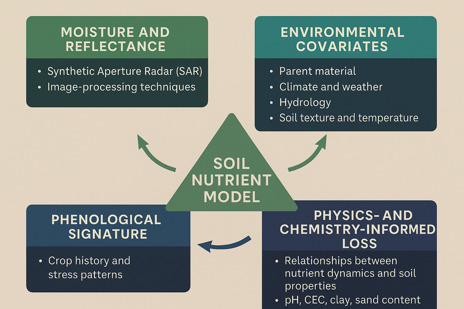
Optical satellite imagery captures reflected sunlight from soil and vegetation, but its readings can be distorted by surface moisture. To reduce this effect, we use Synthetic Aperture Radar (SAR) data alongside reflectance information. SAR provides an independent measurement that reacts differently to moisture, allowing us to correct for its influence. While SAR cannot completely remove the impact of soil water content, it significantly reduces uncertainty compared to using optical data alone.
We further apply image-processing techniques to suppress noise, atmospheric interference, and scattering caused by surface roughness—ensuring a cleaner, more interpretable reflectance signal.
Integrating Environmental and Geological Context
Soil formation depends on geology, topography, and climate. To capture this context, we include auxiliary covariates as priors in our model:
- Parent material and geological age
- Local climate and weather patterns
- Hydrological indices (e.g., Topographic Wetness Index, TWI)
- Soil texture and temperature
These variables help the model differentiate soils that may appear spectrally similar but have very different properties. For example, a sandy soil and a loamy soil might reflect light in comparable ways, but behave entirely differently in nutrient retention and water holding capacity.
Capturing Crop History and Stress Patterns
In addition to static soil features, we analyze time-series imagery from previous growing seasons to extract a phenological signature. This represents the crop’s development and stress patterns throughout the season. Such signals can be indicative of nutrient imbalances or toxicities.
While crop stress can also arise from other factors like drought or pest pressure, integrating phenological data provides valuable context that improves the reliability of our soil nutrient predictions.
Physics- and Chemistry-Informed Constraints
Soil spectroscopy faces the challenge of overlapping signals—nutrient deficiencies can produce similar reflectance or stress responses. To mitigate this, our model incorporates a physics- and chemistry-informed loss function.
This mechanism embeds established relationships between soil properties (pH, cation exchange capacity, clay, and sand content) and nutrient dynamics such as availability and competition. Because properties like pH and CEC are robustly detectable at moderate resolutions, they serve as stable anchors that guide the model toward physically consistent outputs.
The result is a model that avoids implausible outcomes and maintains chemical realism, even when data is limited or noisy.
Bridging Data and Soil Science
By fusing radar, optical, and contextual data with physics-informed learning, our approach produces nutrient estimates that more closely align with real-world soil conditions. This balance between data-driven inference and soil-science knowledge allows for interpretable, reliable, and field-ready results—helping farmers transition from traditional observation to data-based management.
Ongoing Validation and Collaboration
We continuously validate our results through real field data. Across multiple European regions, farmers and agronomists have confirmed that our nutrient maps correspond well with local soil sampling.
As we expand testing to other continents, we invite collaboration from agricultural professionals, research institutions, and input suppliers. Access to diverse benchmark samples helps us identify local nuances and refine regional performance.
Those interested in testing our system can contact us via the Siora Contact page or explore our Open Soil Datasets to see the kind of outputs our model produces.